Earth Catastrophes and Shifting Poles
In 1958
Charles Hapgood suggested that the Earth's crust had undergone repeated displacements
and that the geological concepts of continental drift and sea-floor spreading
owed their secondary livelihoods to the primary nature of crustal shift.
According to Hapgood, crustal shift was made possible by a layer of
liquid rock situated beneath the surface of the planet. A pole shift would thus
displace the Earth's crust in around the inner mantle, resulting in crustal
rock's being exposed to magnetic fields of a different direction.
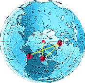 |
Looking down on the current
North Pole, we can identify at least 3 previous positions of the
pole, according to Hapgood. These are shown roughly by the numbered
red dots on the globe.
Position #1 - Yukon area of North America moving east. Position #2 - Greenland Sea moving south-west. Position #3 - Hudson Bay area moving to its present location. |
Earth Crust Displacement
"In 1958 Charles Hapgood suggested in his book The Earth's Shifting Crust that the Earth's crust had undergone repeated displacements and that the geological concepts of continental drift and sea-floor spreading owed their secondary livelihoods to the primary nature of crustal shift. According to Hapgood, crustal shift was made possible by a layer of liquid rock situated about 100 miles beneath the surface of the planet. A pole shift would thus displace the Earth's crust in around the inner mantle, resulting in crustal rock's being exposed to magnetic fields of a different direction." [1]
Pole Shifts & Earth Crust Displacement
"An earth crust
displacement, as the words suggest, is a movement of the ENTIRE
outer shell of the earth over its inner layers. If you remove the peel from an
orange and then reattach it to the fruit you can visualize the possibility of
the peel moving over the inner layers. The earth's crust, according to Charles
Hapgood, can similarly change its position over the inner layers. When it
does the globe experiences climatic change. The climatic zones (polar,
temperate and tropical) remain the same because the sun still shines on the
earth from the same angle in the sky. From the perspective of people on the
earth at the time, it appears as the sky is falling. In reality it is the
earth's crust shifting to another location. Some land moves towards the
tropics. Others shift, with the same movement, towards the poles. Yet others may
escape such great changes in latitude.
 |
The consequence of such a
movement of the entire outer shell of the earth is catastrophic. Throughout the
world massive earthquakes shake the land and enormous tidal waves crash into
and over the continental shelf. As the old ice caps leave the polar zones they
melt, raising the ocean level higher and higher. Everywhere, and by whatever
means, people seek higher ground to avoid an ocean in upheaval."[2]
Vavilov found a direct correlation between agricultural origins and lands more than 4,920 feet above sea level.
Vavilov found a direct correlation between agricultural origins and lands more than 4,920 feet above sea level.
"Working on the assumption
that the earth's magnetic poles are usually close to the poles of rotation, Hapgood
collected geomagnetic rock samples, finding evidence that the most recent
earth crust displacement must have occurred between 17,000 to 12,000 years ago.
The North Pole would have moved from the Hudson Bay area of northern Canada to
it's current place in the Arctic Ocean. More recently, Langway and Hansen
(1973) gathered climactic data pointing to a dramatic change in climate at
12,000 years ago. At that time, the Pleistocene extinctions, rising ocean
levels, the close of the ice age, and the origins of agriculture all seem to
coincide."[3]
Earth Crust Displacement: Effects and Evidence
In his best-selling book Earth
in Upheaval, historian Immanuel Velikovsky gave an account
of what might be expected when the Earth tilts on it's axis:
'Let us assume, as a working
hypothesis, that under the impact of a force or the influence of an agent - and
the Earth does not travel in an empty universe - the axis of the earth shifted
or tilted. At that moment an earthquake would make the globe shudder. Air and
water would continue to move through inertia; hurricanes would sweep the Earth,
and the seas would rush over continents, carrying gravel and sand and marine
animals, and casting them onto land. Heat would be developed, rocks would melt,
volcanoes would erupt, lava would flow from fissures in the ruptured ground and
cover vast areas. Mountains would spring up from the plains and would climb and
travel upon the shoulders of other mountains, causing faults and rifts. Lakes
would be tilted and emptied, rivers would change their beds; large land areas
and all their inhabitants would slip under the sea. Forests would burn, and the
hurricanes and wild seas would wrest them from the ground on which they grew
and pile them, branch and root, in heaps. Seas would turn into deserts, their
waters rolling away.
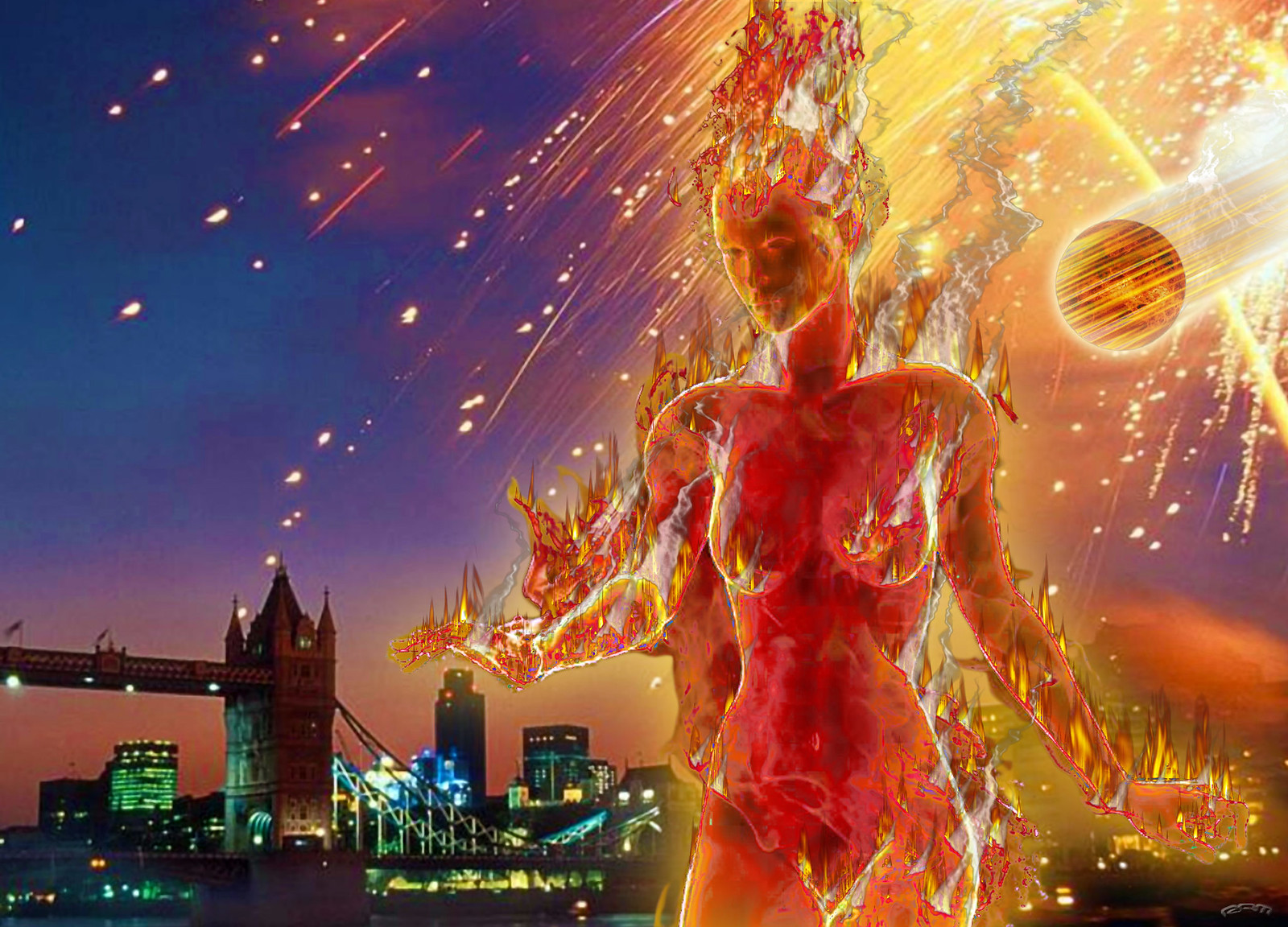
'And if the change in the velocity of the diurnal rotation [slowing the planet down] should accompany the shifting of the axis, the water confined to the equatorial oceans by centrifugal force would retreat to the poles, and high tides and hurricanes would rush from pole to pole, carrying reindeers and seals to the tropics and desert lions to the Arctic, moving from the equator up to the mountain ridges of the Himalayas and down the African jungles; and crumbled rocks torn from splintering mountains would be scattered over large distances; and herds of animals would be washed from the plains of Siberia. The shifting of the axis would change the climate in every place, leaving corals in Newfoundland and elephants in Alaska, fig trees in northern Greenland and luxuriant forests in Antarctica. In the event of a rapid shift of the axis, many species and genera of animals on land and in the sea would be destroyed, and civilizations, if any, would be reduced to ruins.'[4]
'And if the change in the velocity of the diurnal rotation [slowing the planet down] should accompany the shifting of the axis, the water confined to the equatorial oceans by centrifugal force would retreat to the poles, and high tides and hurricanes would rush from pole to pole, carrying reindeers and seals to the tropics and desert lions to the Arctic, moving from the equator up to the mountain ridges of the Himalayas and down the African jungles; and crumbled rocks torn from splintering mountains would be scattered over large distances; and herds of animals would be washed from the plains of Siberia. The shifting of the axis would change the climate in every place, leaving corals in Newfoundland and elephants in Alaska, fig trees in northern Greenland and luxuriant forests in Antarctica. In the event of a rapid shift of the axis, many species and genera of animals on land and in the sea would be destroyed, and civilizations, if any, would be reduced to ruins.'[4]
Neither Hapgood nor Velikovsky
were pulling theories out of the air. The theory that the terrestrial crust is
swimming on magma was first offered in the 1850's. The record of bones and
trees, and shells and layers of sediment that had been found throughout the
world pointed to one or more cataclysms in the Earth's past, some of them as
recently as 1,500 B.C.E. and amazingly, 800 B.C.E. Velikovsky sums up
the scientific establishment's past record on answering the questions:
What caused tropical forests to
grow in polar regions? What caused volcanic activity on a great scale in the
past and lava flows on land and in the ocean beds? What caused earthquakes to
be so numerous and violent in the past? Puzzlement, despair, and frustration
are the only answers to each and every one of these phenomena.
The theories of uniformity (or
gradualism) and evolution maintain that the geological record bears witness
that from time immemorial, even from the time this planet began it's existence
only minute changes - caused by the wind blowing on rocks, the sand grains
swimming to the sea - accumulated into vast changes. These causes however, are
inadequate to explain the great revolutions in nature, and they evoke the
expressions of futility on the part of the specialists, each in his field.
Velikovsky continues with his account:
... The evidence is
overwhelming that the great global catastrophes were either accompanied or
caused by shifting of the terrestrial axis or by a disturbance in the diurnal
and annual motions of the Earth ... The state of lavas with reversed
magnetization, hundreds of times more intensive than the inverted terrestrial
magnetic field could impart, reveals the nature of the forces that were in
action ... Many world-wide phenomena, for each of which the cause is vainly
sought, are explained by a single cause: the sudden changes in climate,
transgression of the sea, vast volcanic and seismic activities, formation of
ice cover, pluvial crises, emergence of mountains and their dislocation, rising
and subsidence of coasts, tilting of lakes, sedimentation, fossilization, the
provenance of tropical animals and plants in polar regions, conglomerates of
fossil animals of various latitudes and habitats, the extinction of species and
genera, the appearance of new species, the reversal of the Earth's magnetic
field, and a score of other world-wide phenomena.[4]
Look into any one of the above
fields and you will begin to see the same pattern Velikovsky, Hapgood,
Einstein and hundreds of other independent geologists, paleontologists and
archeologists have recognized in the Earth's past. A pattern of repeated,
catastrophic change thought to be brought about by crustal displacements
activated by one or more outside agents - such as passing comets or
fluctuations in the sun's own magnetic field - appears to have been with
humanity and its civilizations from the very dawn of mankind.
Rand and Rose Flem-Ath discussed earth-crust displacement' in their book, When the Sky Fell. Seeing evidence of it in almost all parts of the world they described it's effects and the consequences for mankind today. The displacement that happened, according to them at about 11,000 BC, had:
Rand and Rose Flem-Ath discussed earth-crust displacement' in their book, When the Sky Fell. Seeing evidence of it in almost all parts of the world they described it's effects and the consequences for mankind today. The displacement that happened, according to them at about 11,000 BC, had:
'... also left other evidence
of its deadly visit in a ring of death around the globe. All the continents
that experience rapid and massive extinctions of animal species (notably the Americas
and Siberia) underwent massive changes in their latitudes...
'And coral has been found in Newfoundland,
ferns, fossils, coal and fossilized tree-stumps have been found in Antarctica,
water lilies and fossilized palm leaves ten and twelve feet long have been
found in Spitzbergen, there is evidence that the swamp cypress
flourished within 500 miles of the North Pole in the Miocene epoch, and more.
The evidence is overwhelming that the Poles have not covered the same parts of
the planet for the entire extent of our geological history.
'The consequences of the displacement are monumental. The earth's crust ripples over its interior and the world is shaken by incredible quakes and floods. They sky appears to fall as continents groan and shift position. Deep in the ocean, earthquakes generate massive tidal waves which crash against the coastlines, flooding them. Some lands shift to warmer climes, while others, propelled into polar zones, suffer the direst of winters. Melting ice caps raise the ocean's level higher and higher. All living things must adapt, migrate or die ...
'If the horror of an earth-crust displacement were to be visited upon today's interdependent world the progress of thousands of years of civilization would be torn away from our planet like a fine cobweb. Those who live near high mountains might escape the global tidal waves, but they would be forced to leave behind, in the lowlands, the slowly constructed fruits of civilization. Only amongst the merchant marine and navies of the world might some evidence of civilization remain. The rusting hulls of ships and submarines would eventually perish but the valuable maps that are housed in them would be saved by survivors, perhaps for hundreds, even thousands of years. Until once again mankind could use them to sail the World Ocean in search of lost lands ...'[3]
That something such as this
could have happened to the earth seems, in our forward-looking culture of
progress, somehow unbelievable. We are not taught such concepts at
school nor are we brought up to think in this way. Suggesting that it could
happen in the future can earn everything from the epithet of 'prophet of doom'
to outright academic scorn. Nevertheless, look into the holy works and records
of the ancient civilizations and you will find corroboration from what remains
of the 'media' of their time, their mythology, legends and folklore. Cataclysmic
events on a global scale did strike the civilizations of the ancients, and
many recorded it in the clearest and most intelligible ways they were capable
of at the time. The accounts survive throughout the world to this day only as a
number of so-called myths about earth-rending, global catastrophes.
[1] Adrian
G. Gilbert & Maurice Cotterell. The Mayan Prophecies. Element Books, 1995.
ISBN 1-85230-888-5
[2] Rand & Rose Flem-Ath (Discovering Atlantis)
[3] Rand and Rose Flem Ath, When the Sky Fell. In Search of Atlantis. Orion Books, 1996. ISBN 0 75280 171 6
[4] Immanuel Velikovsky. Earth in Upheaval. 1955. ISBN 0-671-45282-7
[2] Rand & Rose Flem-Ath (Discovering Atlantis)
[3] Rand and Rose Flem Ath, When the Sky Fell. In Search of Atlantis. Orion Books, 1996. ISBN 0 75280 171 6
[4] Immanuel Velikovsky. Earth in Upheaval. 1955. ISBN 0-671-45282-7

The
Polar Pivotal Axis
There is no doubt that the Planet Earth’s Polar Axis has shifted during its geological history. Evidence of such shifting can be found all over the world. Any academic difference of opinion resides in the question of exactly when these Polar Axis Shifts occurred. On the one hand, there are traditional scientists and geologists who date these shifts millions of years into the past, stating that there is absolutely no evidence that such shifts occurred within recent geologic times. But on the other hand, there is the Velikovskian School which dictates that at least one of these Polar Axis Shifts, perhaps even two or three of them, occurred within recorded historic times.
This academic disagreement was partly reflected in
what has become known as “The Velikovsky Affair”, in
which mainly Ivy League professors such as the late astronomer Carl
Sagan of Cornell University and the controversial paleontologist Stephen
Jay Gould of Harvard University disputed the science of the theories
of the late Dr. Immanuel Velikovsky of Princeton University. As a
longtime Velikovskian, I belong to the Velikovskian School and
agree that a Polar Axis Shift did indeed occur in historic times, namely
in the 16th Century BCE, as Dr. Velikovsky theorized in Worlds
In Collision; and to wit, exactly in the year 1587 BCE. The North Pole
shifted from a position in the North Atlantic Ocean to its
current Arctic location, and the South Pole shifted from
off the southern coast of Australia to the current Antarctica.
Regardless of which side of the timeframe fence one sits on, there is a single point of agreement amongst everyone, a common perplexity: what were the precise causes of these past Polar Axis Shifts? Most scholars admit that they could not have occurred without the intervention of a powerful external body capable of “torqueing” the Earth from one axis to another; the Earth could not shift on its own, from internally. Speculation has ranged from a giant comet passing too close-by, or an asteroid hitting the Earth, or some unknown “cosmic body” passing in our vicinity, all on a purely unpredictable and random basis. To date, however, no one has devised a completely satisfactory explanation for this mysterious phenomenon. Apparently, no one knows the answer as yet.
Here I am proposing that the “cosmic agent” causing these periodic Polar Axis Shifts is the nomadic Rogue Planet X Nibiru, which was responsible for the previous catastrophe in the 16th Century BCE. So far, no one else, including Zecharia Sitchin or even anyone within the Velikovskian School, has proposed such an alternative theory. And I also propose that these shifts are predictable both in time and location, because these shifts occur once every 3,600 years along Polar Belts determined by a Polar Pivotal Axis, which is a line drawn straight down through the top of the Great Pyramid of Egypt and coming out in the Mid-Pacific Ocean at 30 degrees south latitude and 150 degrees west longitude, exactly opposite the Pyramid which is at 30 degrees north latitude and 30 degrees east longitude. The arrival sequence of the Planet X Nibiru and its attempt to tether itself to Earth’s North Polar Belt by the use of an electromagnetic beam results in a pivoting, or torqueing effect, causing the Pyramid-Oceania Polar Pivotal Axis to tilt to New Polar Zones.
HOWEVER, the Great Pyramid Complex
itself would STILL be located 30 degrees above the NEW Equator and 60 degrees
south of the NEW North Pole, as it is today. The same would be true for the
opposite pivotal point in Oceania. ONLY these two locations would have the same
latitudinal position as before, 30 degrees above the Equator and 60 degrees
away from their respective Poles. Every other geographic location on Earth
would change, some by not very much, others greatly by comparison.
And here the proposition is taken for granted that there were no traditional “Ice Ages”, that these so-called “Ice Ages” simply reflect the presence of Polar Ice in various other Polar Zones around the globe. The ice of the present-day North and South Poles did NOT expand southwards and northwards, causing these strange icesheets in otherwise unfrozen modern locations. Nevertheless, the locations of these ice-sheets would be most critical with respect to the creation of a pattern of shifting. Primarily in Earth In Upheaval, Dr. Velikovsky described many anomalies of geological evidence from around the world. A good example would be the existence of extinct tropical coral reefs underneath the present North Polar Ice, indicating that at one epoch in time our now-frozen Arctic Ocean had a tropical climate.
Dr. Velikovsky gives us evidence of
ice-sheets in India, South Africa, Northeastern Brazil, Ghana, North America,
Europe, Mexico, Hawaii and Australia. If one plots these various locations on a
world globe, one immediately notices how they tend to ring the area of Egypt,
at a distance of about 50-60 degrees in all directions. Furthermore,
there is absolutely no evidence of an “Ice Age” in the modern Middle
East itself. It is from that point of view that I began—in 1973—to make
my assumptions regarding the Great Pyramid of Egypt as having
been deliberately built in that geographic location, amongst other reasons, “to
mark the spot” of the Polar Pivotal Axis. That, of course, is
a most radical supposition, and I am the first to admit it.
If one disassembles a world globe and inscribes upon it a circle with its center at Cairo and a radius from there to the current North Pole, that circle would become the North Polar Belt. Similarly, if one inscribes a circle with its center exactly opposite Cairo in Oceania and a radius to the South Pole, that circle would become the South Polar Belt. These two circles would denote the thickest parts of the icesheets in other locations, with Polar Ice extending away from those lines in proportion to what it extends today outwards from the Arctic and Antarctic. All “Ice Ages” fall within these Polar Belts, and there is no evidence of “Ice Ages” in other locations. Coincidence? You decide.
Next, if one further inscribes an equatorial line between the Pyramid-Oceania Polar Pivotal Axis, this line would become a Pyramid-Oceania Polar Pivotal Equator; and it would divide the globe into two Polar Hemispheres,
·
a North Polar Hemisphere
with its center at the Great Pyramid of Egypt
·
and a South Polar Hemisphere with its
center in Oceania, separating these two hemispheres exactly halfway between the
North and South Polar Belts.
All geographic locations along this Pyramid-Oceania
Polar Pivotal Equator would NEVER experience or have experienced extreme
polar glaciation of any sort. This line passes through the following modern
geographic locations:
·
Central Wisconsin
·
Central Minnesota
·
Northwestern Canada
·
Anchorage
·
Okinawa
·
Mindanao
·
Celebes
·
Bali
·
South Indian Ocean
·
South Atlantic Ocean
·
Rio de Janeiro
·
Caracas
·
Haiti
·
South Carolina
·
and back to Central Wisconsin, which boasts along
its southwestern highways how that part of the state was never glaciated in an
“Ice Age” and has been officially classified as a “Driftless Area”
Here is what is inscribed on one such sign, erected
in 1983 beside Interstate Highway 90 northwest of Madison, Wisconsin:
“Several times during the ice ages, glaciers flowed
out of Canada, sometimes reaching as far south as the Ohio and Missouri rivers.
During recent glaciations, southwestern Wisconsin was untouched, because the
glaciers were diverted to the east or west by the highlands of north-central
Wisconsin and northwestern Michigan. Here, in the Driftless Area,
you see a rugged landscape with deep valleys and rocky crags. Much of the
Midwest would look like this today if it had not been glaciated, but the ice
sheets smoothed those areas by eroding away the crags and filling in the
valleys. The Driftless Area was never completely surrounded by ice, and
the glaciers reached only its eastern edge during the last glacial episode. At
that time, about 15,000 years ago, the Wisconsin River was dammed by the
glacier, and the sediment deposited in glacial Lake Wisconsin forms the flats
between Tomah, Wisconsin Dells and Wisconsin Rapids. Then the Driftless Area
was treeless and had a tundra climate.”
Such areas like Anchorage, which is near the Arctic
Circle and therefore cold and wintry, is itself never under the greater
part of a Polar Icecap, despite the presence of several technical glaciers in
its general vicinity. St. Petersburg, Russia, is at the same
60-degree north latitude as Anchorage, and we certainly do not consider modern
St. Petersburg to be “glaciated”. Anchorage, incidentally, will
someday be in a comparable southern location as it is today, when a future
South Pole will be located just northeast of the Hawaiian Islands, except that
Anchorage will be the same distance from that SOUTH Pole, not North Pole.
Although it would actually be impossible from existing evidence to predict exactly where on the Polar Belts each succeeding Polar Alignment would be located, in that these shiftings could be either random or systematic, it is the hypothesis here that they shift in an orderly fashion in a CLOCKWISE manner when viewed from the overhead perspective of the Great Pyramid of Egypt. As Dr. Velikovsky’s theoretical North Pole shifted from the North Atlantic to the Arctic in a clockwise manner, so also might the next shift be in the same clockwise direction from the Arctic towards Mongolia and the previous shift have been from the Mid-Atlantic to the North Atlantic.
After one prepares a world globe to represent all of the various Polar Zones and Equators, as well as the Pyramid-Oceania Polar Pivotal Equator, one can spend many hours speculating about this or that detail. For example, if the North Pole were located in the Mid-Atlantic Ocean between Luanda, Angola, and Recife, Brazil, and the South Pole were located just southwest of the Marshall Islands, then the resulting Equator would pass through Antarctica and travel across the presently eastern Pacific Ocean to Acapulco, Mexico City, Laredo, Dallas, Tulsa, Kansas City, Minneapolis, Hudson Bay, Northern Greenland, Spitzbergen Island and then go across the Barents Sea into Russia, pass through Perm and the Aral Sea, and stretch into Afghanistan, Pakistan and Western India before heading out into the Indian Ocean via Diego Garcia, back to Antarctica. In such a Polar Alignment, the present-day Arctic Ocean would be located near the equatorial tropics and would certainly contain coral reefs of which, as was noted, we have modern evidence.
And many other similar observations can also be
made, when one considers various areas of the world which have apparently
undergone extreme climatic changes from equatorial to polar (Arctic), which
used to be forests but now are deserts (Saudi Arabia), or which used to be
under the ocean but now are dry land (Texas). My demonstration of this “polar
globe” was not included in the 2003 video, Planet X - Assessing The Science,
which is available for purchase Planet X Video. At a June 1999 Catastrophism
Conference, hosted by Professor Emilio Spedicato at the University
of Bergamo in Italy, a number of respected authors and researchers
presented a series of papers and lectures. Reprinted below, as they appeared in
the September 2000 edition of The Velikovskian Journal (Volume V, Number 1)
published by Charles Ginenthal in New York, are three “abstracts” or
overviews of these papers and lectures, as they pertain to Polar Axial
Displacement.
CHANGES in the ROTATION AXIS of EARTH AFTER ASTEROID or COMETARY IMPACTS
By Flavio Barbiero
Centro Camuno di Studi Preistorici
Capodiponte, Italia
Evidence exists that the poles have changed
position during the recent past in a very rapid way—in a
matter of days. This possibility, however, so far has been disregarded by
official science on the basis that such a phenomenon is thought to be
physically impossible: no mechanism is known and no energy capable of provoking
it. The hypothesis that the inclination of the terrestrial axis in relation to
the ecliptic and the position of the poles might change has however been taken
into consideration since last century.
Some of the greatest scientists of the time,
including J.C. Maxwell and Sir George Darwin, considered this
problem but decided that the stabilizing effect of the equatorial bulge was so
great that no conceivable force originating within the Earth could lead to a
shifting of the axis, except for the collision with another planet.
They did not take into account, however, the phenomena of instability which could occur to an Earth-like gyroscope, consisting of a plastic shell, easily deformed by centrifugal forces, covered by freely-moving liquids—the only body of this kind in the solar system.
Our work shows that the impact of extraterrestrial objects as small as an Apollo class asteroid could “trigger” a process which in a matter of days would cause a “reshaping” of the equatorial bulge around a different axis, inducing therefore a shift of the poles and a change of the tilt. In order to trigger the process, the peak value of the torque developed by the impact has to overtake a “threshold” value, equal to the stabilizing torque developed by the equatorial bulge. A rough calculation shows that the threshold value can be reached during the impact with a body much smaller than a one-kilometer-sized asteroid.
A shift of the poles would cause worldwide destructive phenomena such as:
·
earthquakes and volcanic activity in all areas
interested [sic] by adjustments of the crust
·
violent winds and torrential rains, with
unprecedented floods all over the world
·
wide fluctuations of the oceans’ level, with
subsequent temporary submersion of large parts of the continents
·
perturbation of the magnetic field
On top of that, there would be permanent changes of
the climate, due on one side to the shift of the poles (and therefore to a
change of latitude of many regions, deviation of oceanic and atmospheric
currents and so on); on the other side, to the change of the tilt, with
subsequent modification of the seasonal pattern. A shift of the poles occurring
at the end of the Pleistocene, with all its related destructive phenomena,
could explain coherently the climatic situation before that date, and the
situation observed after that date, as well as ancient traditions about a
worldwide catastrophe.

The DELUGE in the PEOPLES’ TRADITIONS and GEOLOGICAL
EVIDENCE
By Alexander Tollmann
University of Vienna, Austria
In 1992 the geologists Edith and Alexander
Tollmann published a monograph which claimed that the Noachian Deluge was
the consequence of a cometary impact about 9,500 years ago. A series of
geological facts supported the claim, together with a critical analysis of
mankind’s traditions. Geological proofs of the impact include a crater with
iridium, shatter cones, stress lamination of minerals, radiocarbon dating,
dendrochronology, a peak of acid in the Greenland and so on. Over a thousand
worldwide traditions describe moreover every detail of the catastrophe
following the impact and the spiritual consequences on the human mind. In our
present communication we will add new proofs of the impact.
They include analysis of the Koefels crater
in Tyrol and new radiocarbon dating. The hiatus of settlements for this time is
recorded from many places in the world, both from villages and caves. The
impact led to the development of religions, to a confusion of languages, to the
transition from a hunting and collecting economy to an agricultural and
cattle-breeding economy and so on. Another impact, the “Late-Glacial Impact”,
occurred as a forerunner about 3,500 years before the Noachian Flood. We have
been led to its existence by several indications: torrential rainfalls, fallout
of nitric acid, the extinction of most of the Pleistocene mega-mammals…The
Late-Glacial Impact is also supported by the discovery of its conflagration
(Weltenbrand) horizon, which has been documented by J.B. Kloosterman in
more than a dozen countries on three continents. The epoch of this impact is
the Allerod time, about 13,000 BP [that is, BCE], still in the younger
Paleolithic (Termination IA), whereas the Noachian Flood Impact occurred in the
Mesolithic (Termination IB), about 9,500 years BP. The Late-Glacial Impact was
caused by a comet: its fragments struck the northern hemisphere, in particular
the ice of the Canadian Ice Shield, leading to the giant “Debacle” flood
(Ontario, 450 km. wide) and the Spokane Flood, in the Columbia Basin.
DENDROCHRONOLOGICAL DATING, RESULTS and OPEN
PROBLEMS
By Mark Baillie
Queen’s University, Belfast, United Kingdom
The availability of long, year-by-year, tree-ring
chronologies from a spread of locations has allowed the exploration of
several abrupt, apparently catastrophic, environmental events in recent
millennia. This paper will explore the ways in which data are accumulating
relevant to these events. It will also explore the chronological pitfalls
encountered when evidence from sources of differing dating quality are
encountered. In many cases there are definite limits to the precision with
which environmental parameters can be dated. This applies particularly to
palynological and sedimentary records; even varve records and ice-cores have
their limitations when it comes to highly refined dating questions. Currently
it is fair to say that, for anything earlier than the present millennium, there
is no good understanding of the causes of the various environmental downturns
noted in the tree-ring records. The paper will also explore some of the
possibilities which have been tentatively addressed so far, namely volcanism, extraterrestrial
bombardment and undersea outgassing.
In 1984 Val LeMarche and Kathy Hirschboeck pointed out a severe frost ring in the Californian bristlecone pine tree-ring record relating to the calendar year 1627 BC. Their suggestion that this frost event might have been due to the eruption of the Santorini volcano in the Aegean is still a source of active debate. Their work stimulated the observation of a series of narrowest-ring events in an Irish oak chronology at dates 3195 BC, 2345 BC, 1159 BC, 207 BC and AD 540. These dates, it turns out, fall in the vicinity of several possibly traumatic environmental events marked in human records by such phenomena as dynastic changes, Dark Ages and plagues (Baillie, 1995). Circumstantial cases can be erected which would allow the environmental downturns to explain some of the human effects.
Curiously, mythology hints that several of the
events may have had cometary associations. Such cases then allow the
formulation of research programs aimed at uncovering physical evidence from
suitable deposits. Detailed examination of oak specimens in which the
narrowest-ring events were observed, and consideration of the detailed
responses of trees in various geographical areas to the events, hint at complex
reactions over periods of years; and it may be some considerable time before
definitive solutions are available. In the meantime, active speculation in the
literature is aimed at flushing out relevant information from specialists in a
wide variety of fields.
Note that in these “abstracts” the authors ASSUME
that some sort of “cometary impacts” were necessary to trigger these
axis shifts. It is highly significant that existing records of the Planet
X Nibiru, as Zecharia Sitchin has described in The Earth
Chronicles, suggest that it is “cometary” in appearance because of its
“tail” which is in fact nothing more than the electromagnetic tethering beam
that it unleashes in order to attach its South Pole to our North Polar Belt.
And, of course, the “Venus” of Dr. Velikovsky was “cometary”
in nature. These “abstracts” demonstrate further the difficulty that one
encounters in determining a cause for Polar Axial Displacement outside
the framework of the periodical returns/arrivals of the Planet X Nibiru,
not to mention the futility of calculating exactly when each repetition recurs
if they are considered as “random” rather than predictable events within this
Solar System.
Transcribed below is an article from The Dallas Morning News. It contains a perfect example of the fallacy of trying to explain historical climate changes by traditional methods. The academic scientific establishment is so blind to and afraid of the possibility of catastrophic planetary changes in “recent times” that their entire system of dating these events is flawed from the outset. As Dr. Carl Sagan might have remarked sarcastically to Dr. Immanuel Velikovsky during the course of The Velikovsky Affair,
“There is no evidence of such catastrophes in
recent geologic time; they occurred MILLIONS and MILLIONS of years ago!”
Everybody is free to choose the “school” in which
he or she may wish to believe. I chose “Catastrophism & Ancient History”
years ago, The Velikovskian School. This recent evidence below can be
explained quite logically if one is aware of the theoretical possibility of a Polar
Pivotal Axis reaching from Cairo to Oceania, generating Polar
Pivotal Belts where North and South Polar Zones are periodically located, as a
result of the recurrent transits of the “custodial” Planet X Nibiru,
the cyclical “Cosmic Tree”.
If, as both Dr. Velikovsky and I have suggested, the last North Pole was located in the North Atlantic Ocean, then polar ice, other glaciation and permafrost would have extended into northeastern North America, western Europe and Morocco. During such a scenario, Haiti, Cuba and Florida would have been located about the same distance from that North Pole as Anchorage and St. Petersburg are located away from the present North Pole.
The Gulf of Mexico would naturally have been much cooler, since it would have been equivalent geographically to, say, that stretch of the current cold Pacific Ocean from Anchorage to Seattle. Yucatán, Mexico, would have been situated about the same distance from that North Pole as Oregon is from the current pole. Moreover, if the South Pole were located about 1,000 miles (1,600 kilometers) off the Pacific coast of Mexico, southwest of modern Acapulco, then the northeastern half of the Gulf of Mexico would have been located just north of that South Polar Zone, Miami and Havana again at about the same latitude away, but in the south, as Anchorage is today in the north; and the southwestern Gulf, southwestern Texas, all of Mexico and Central America, the Galapagos Islands, and west-coastal Colombia and Ecuador would have been within that South Polar Zone (permanent ice to permafrost). Since West Texas was at one time under the ocean, it is logical to assume that when the South Pole is located off Acapulco and/or when the North Pole is located in the North Atlantic Ocean, then Texas is underwater. That’s my guess, at least, for what it’s worth.
Thus, this “new evidence” is perfectly explainable by The Velikovskian School. When a new theory is inherently true, all of the peripheral facts, like this one, that come along the pipeline, will automatically fall into place like clockwork.
Except for the standard but flawed establishment
dating here, which Sagan would have supported, this is a classic example…
From Bibliotecapleyades @ http://www.bibliotecapleyades.net/sitchin/esp_sitchin_3g.htm and http://www.bibliotecapleyades.net/hercolobus/planetx/planetX02.htm - much more at the second link.
For more information about pole shift see http://nexusilluminati.blogspot.com/search/label/pole%20shift
- See ‘Older Posts’ at the end of each section
This is a ‘not for
profit’ site -
But if you like what we do please
buy us a meal if you can
Donate any amount and receive at least one New Illuminati eBook!
Please -
http://upload.wikimedia.org/wikipedia/commons/thumb/b/ba/Venus_pentagram.png/646px-Venus_pentagram.png
http://upload.wikimedia.org/wikipedia/commons/a/aa/Red_Giant_Earth_warm.jpg
http://upload.wikimedia.org/wikipedia/commons/6/61/AxialTiltObliquity.png
For further enlightening
information enter a word or phrase into the random synchronistic search box @ http://nexusilluminati.blogspot.com
And see
New Illuminati – http://nexusilluminati.blogspot.com
New Illuminati on Facebook - https://www.facebook.com/the.new.illuminati
New Illuminati Youtube Channel - http://www.youtube.com/user/newilluminati/feed
New Illuminati on Google+ @ https://plus.google.com/115562482213600937809/posts
New Illuminati on Twitter @ www.twitter.com/new_illuminati
The Her(m)etic Hermit - http://hermetic.blog.com
The Prince of Centraxis - http://centraxis.blogspot.com (Be Aware! This link leads to implicate &
xplicit concepts & images!)
DISGRUNTLED SITE ADMINS PLEASE NOTE –
We provide a live link to your original material on your site - which
raises your ranking on search engines and helps spread your info further! This site
is published under Creative Commons Fair Use Copyright (unless an individual article
or other item is declared otherwise by copyright holder) – reproduction for non-profit
use is permitted & encouraged, if you give attribution to the work &
author - and please include a (preferably active) link to the original (along
with this or a similar notice).
Feel free
to make non-commercial hard (printed) or software copies or mirror sites - you
never know how long something will stay glued to the web – but remember
attribution! If you like what you see, please send a donation (no amount is too
small or too large) or leave a comment – and thanks for reading this far…
Live long
and prosper!
From the New
Illuminati – http://nexusilluminati.blogspot.com
No comments:
Post a Comment
Add your perspective to the conscious collective